


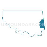
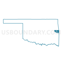
Voting District 105, Sequoyah County, Oklahoma
About
Outline

Summary
| Unique Area Identifier | 655176 |
| Name | Voting District 105 |
| County | Sequoyah County |
| State | Oklahoma |
| Area (square miles) | 30.79 |
| Land Area (square miles) | 30.48 |
| Water Area (square miles) | 0.31 |
| % of Land Area | 99.01 |
| % of Water Area | 0.99 |
| Latitude of the Internal Point | 35.46233030 |
| Longtitude of the Internal Point | -94.47637560 |
Maps

Graphs
Select a template below for downloading or customizing gragh for Voting District 105, Sequoyah County, Oklahoma


Neighbors
Neighoring Voting District (by Name) Neighboring Voting District on the Map
- Voting District 1, Sebastian County, AR
- Voting District 1-K, Sebastian County, AR
- Voting District 102, Sequoyah County, OK
- Voting District 104, Sequoyah County, OK
- Voting District 106, Sequoyah County, OK
- Voting District 108, Sequoyah County, OK
- Voting District 2A, Sebastian County, AR
- Voting District 310, Sequoyah County, OK
- Dora Voting District, Crawford County, AR
- Jasper Voting District, Crawford County, AR
Top 10 Neighboring County Subdivision (by Population) Neighboring County Subdivision on the Map
- Upper township, Sebastian County, AR (76,938)
- Roland CCD, Sequoyah County, OK (9,632)
- Jasper township, Crawford County, AR (2,495)
- Dora township, Crawford County, AR (1,300)
Top 10 Neighboring Place (by Population) Neighboring Place on the Map
- Fort Smith city, AR (86,209)
- Roland town, OK (3,169)
- Remy CDP, OK (562)
- Long CDP, OK (370)
- Moffett town, OK (128)
Top 10 Neighboring Elementary School District (by Population) Neighboring Elementary School District on the Map
Top 10 Neighboring Unified School District (by Population) Neighboring Unified School District on the Map
- Fort Smith Public Schools, AR (89,450)
- Van Buren School District, AR (33,254)
- Cedarville School District, AR (5,220)
- Roland Public Schools, OK (4,957)
Top 10 Neighboring State Legislative District Lower Chamber (by Population) Neighboring State Legislative District Lower Chamber on the Map
- State House District 2, OK (37,808)
- State House District 83, AR (29,916)
- State House District 65, AR (28,566)
- State House District 64, AR (27,265)
Top 10 Neighboring State Legislative District Upper Chamber (by Population) Neighboring State Legislative District Upper Chamber on the Map
- State Senate District 3, AR (87,143)
- State Senate District 13, AR (82,857)
- State Senate District 4, OK (78,222)
Top 10 Neighboring 111th Congressional District (by Population) Neighboring 111th Congressional District on the Map
Top 10 Neighboring Census Tract (by Population) Neighboring Census Tract on the Map
- Census Tract 202.03, Crawford County, AR (7,605)
- Census Tract 301.04, Sequoyah County, OK (6,992)
- Census Tract 2, Sebastian County, AR (5,076)
- Census Tract 203.02, Crawford County, AR (4,251)
- Census Tract 301.03, Sequoyah County, OK (2,640)
- Census Tract 3, Sebastian County, AR (2,640)